Tokachi, Hokkaido — August and September 2025
One wrong base height, and the map is 122 m off
On the same road, at the same places, the two tracks agree to 0.53 m horizontally and differ by 122 m in height. Not multipath, not sky view. This is the record of 22 logs from three days, compared cell by cell.
What was measured
22 NMEA logs from Tokachi in Hokkaido: 20,566 fixes over 199.3 km. RTK worked on two of the days. On the third, corrections never arrived at all.
| Date | Distance | Fixes | Solution | Height range |
|---|---|---|---|---|
| 2025-08-16 | 57.3 km | 4,857 | RTK fixed 90.1% / float 9.1% / single 0.8% | -76.2 to 18.5 m |
| 2025-08-19 | 75.2 km | 9,307 | RTK fixed 74.2% / float 14.8% / single 10.9% | -30.3 to 445.4 m |
| 2025-09-08 | 66.8 km | 6,402 | Single point 100% | 86.0 to 545.7 m |
19 August and 8 September ran the same roads. The two lines sit on top of each other at full extent and still at 280 m across.
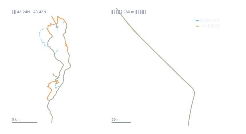
Only the height differs, by 122 m
Positions were binned into cells of roughly 20 m and only cells visited on both days were compared: 2,932 of them. The median difference is 122.37 m, with quartiles at 121.73 m and 122.83 m.
Noise scatters. A spread of about a metre across a whole route is not noise; it is two height references running parallel to each other.
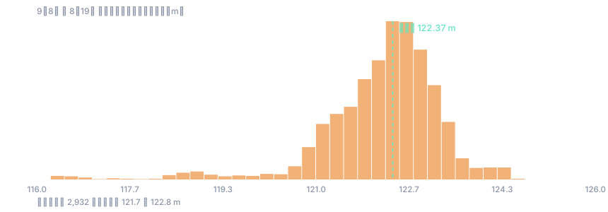
Horizontally the two days agree
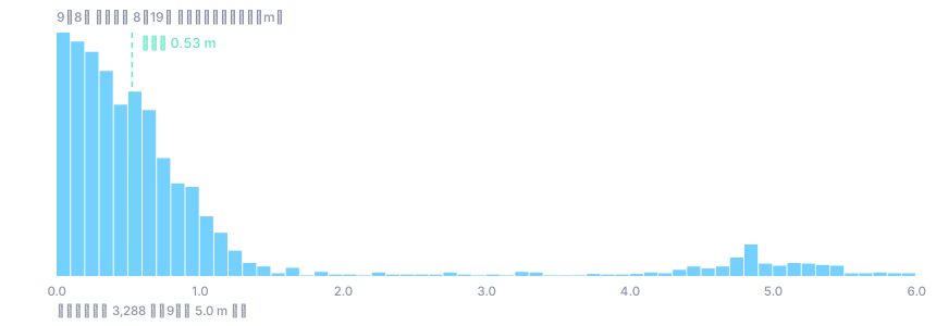
For every fix on 8 September the perpendicular distance to the 19 August line was measured. Across 3,288 matched fixes the median is 0.53 m and three quarters fall within 0.95 m.
That is the width of driving the same lane twice. There is no horizontal offset to find.
Which day is wrong
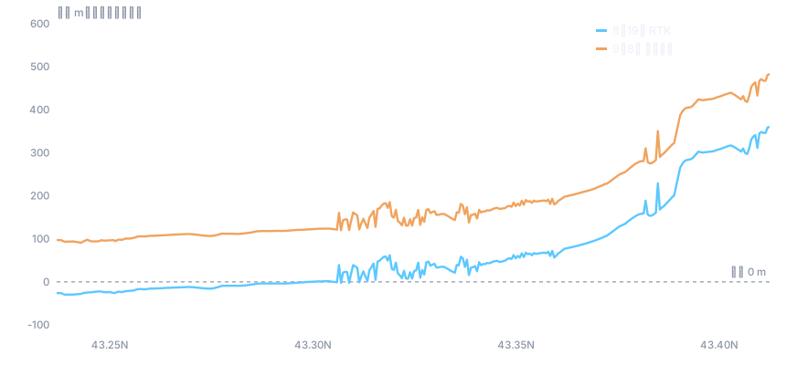
At the southern end, the 19 August record puts the vehicle 30 m below sea level. Inland Tokachi is not below sea level. The day that is wrong is the RTK day.
Why only the height
RTK solves the rover relative to the base. Whatever coordinate the base was given is carried straight into every rover position. If the latitude and longitude are right and only the height was entered too low, only the rover height drops, by exactly that amount. That is the shape seen here.
Geoid separation was logged as 27.33 m to 27.55 m on both days, the same values. This is not a geoid or datum mix up in the file.
Two things were measured: a horizontal agreement of 0.53 m and a height offset of 122.37 m. The receiver and base configuration were not inspected. Attributing the cause to the height entered at the base is the reading consistent with these numbers, not a verified fact.
Running the same check on your own logs
- Drive the same road twice, on different days. One pass cannot reveal a reference offset.
- Keep the raw NMEA. $GPGGA carries height, geoid separation and solution quality.
- Convert it with GPS log converter. It runs in the browser; the log never leaves the machine.
- Bin to cells of about 20 m and take the median height difference over cells both days visited.
- If that difference is tight to within a metre or so, the problem is the reference, not the reception.
Vertical error runs roughly twice horizontal error. Even a single point solution stays within a few metres. An offset measured in hundreds of metres is an entered number, not the sky.
The data behind the figures
Both days are published as GeoJSON, derived from the raw NMEA: position, time, height and solution quality, with the line split wherever the solution quality changes.